Content
Cultural heritage sites around the world face numerous threats, from urbanization and climate change to natural disasters. As these sites are vital for understanding our history and identity, preserving them is crucial. One of the most innovative technologies aiding in this preservation is Spatial LiDAR (Light Detection and Ranging). This blog will explore how Eagle LiDAR technology is transforming the field of cultural heritage preservation.
What is LiDAR?
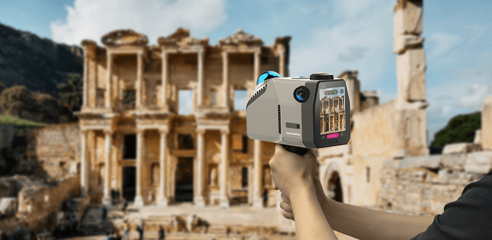
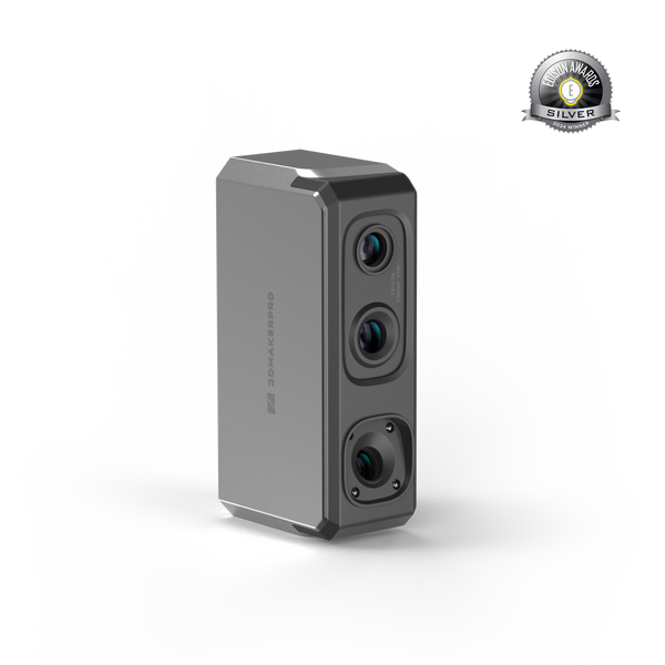
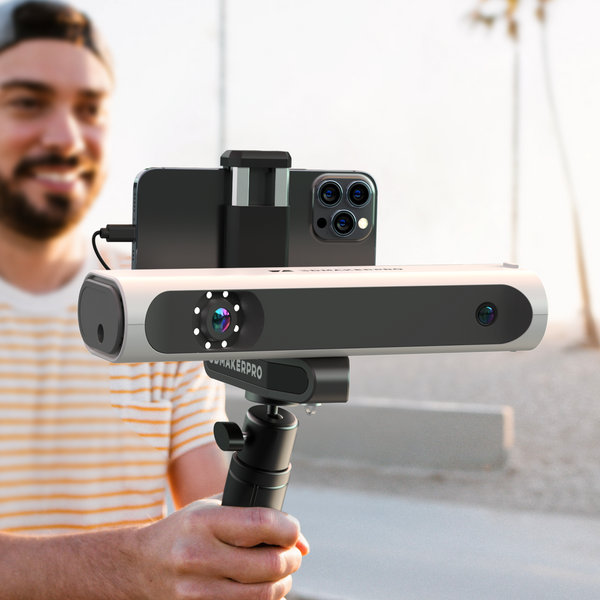
LiDAR is a remote sensing technology that uses laser light to measure distances and create detailed 3D representations of physical environments. Eagle's laser source is 905 nm; the point cloud frequency is 200,000 points/sec, which can quickly scan the features of various complex environments, making it a valuable tool for archaeologists, historians, and cultural relics protectors.

Applications in Cultural Heritage Preservation
a) Historic Sites Documentation and Conservation
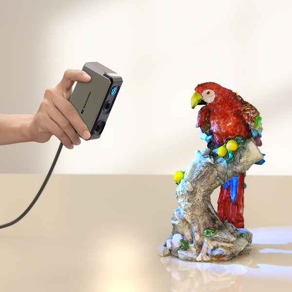
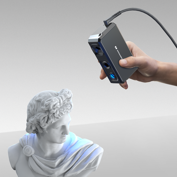
With an impressive point cloud frequency of 200,000 points per second, the Eagle scanner efficiently captures historical sites, significantly enhancing the productivity of archaeologists engaged in data acquisition. Its advanced 1/4 48-megapixel camera system supports 8K panoramic photography and color texture mapping, which allows for comprehensive documentation and preservation of the site. This capability not only restores the most authentic appearance of the location but also aids archaeologists in accurately analyzing the civilization and social development of the era. Importantly, the non-contact laser-based scanning technology minimizes the risk of secondary damage to delicate sites that have recently been excavated, ensuring their integrity is maintained during the documentation process.
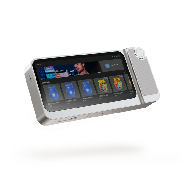
Furthermore, the Eagle's built-in 12,000mAh battery provides an hour of continuous operation, with the added convenience of charging while in use, alleviating concerns about power limitations during fieldwork. The scanner supports multiple output formats, including 3D Color Point Cloud (PLY), 3D Gaussian Splatting (PLY), 3D Colored Polygonal Model (OBJ), and 3D Panoramic Tour Data (OBJ), ensuring that researchers have versatile options for data utilization without the fear of data loss. This comprehensive approach to data management enables the storage of vivid 3D imagery online, offering a more dynamic and engaging representation compared to traditional 2D photographs. Overall, the Eagle scanner is a powerful tool that enhances the archaeological process, making it easier to preserve and analyze our cultural heritage.

b) Cultural Relics Repair and Reconstruction
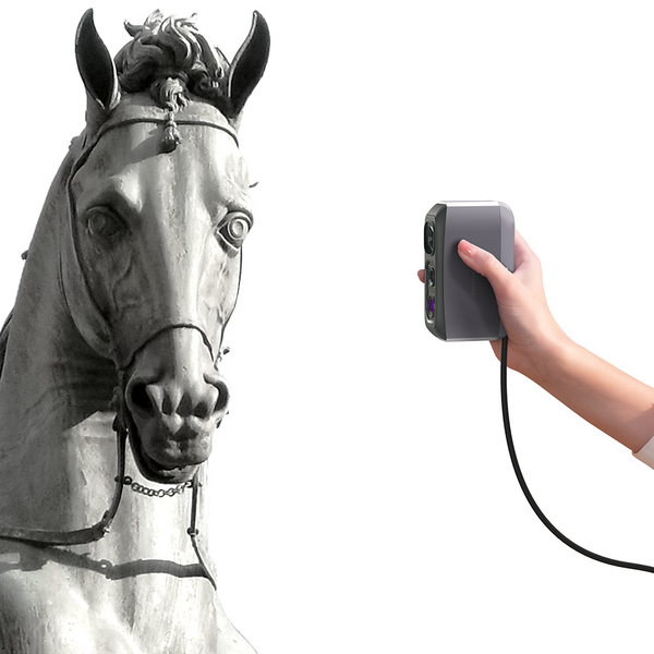
The Eagle scanner exemplifies the transformative impact of LiDAR technology in the field of cultural relics repair and reconstruction, achieving remarkable accuracy with precision levels of 2cm @ 10m, 3cm @ 20m, and 5cm @ 40m. This high level of detail allows for the capture of intricate features, from the delicate textures of artifacts to the smooth surfaces of walls and the complex contours of staircases. With multiple viewing options—first-person, overhead, and at a 45-degree angle—the Eagle adapts seamlessly to the specific requirements of historical sites. Its horizontal scanning angle of 360° and vertical angle of 59° enable it to operate effectively in diverse environments, both indoors and outdoors. Incorporating SLAM (Simultaneous Localization and Mapping) technology along with GPS positioning, the scanner provides real-time tracking and scanning capabilities, ensuring accurate modeling of complex spaces while supporting both absolute and relative coordinate positioning for detailed mapping.
LiDAR scanners, like the Eagle, play a pivotal role in the recovery and preservation of historical sites and cultural relics by generating highly accurate three-dimensional data that captures intricate details without causing physical damage. This technology empowers archaeologists and conservators to create precise digital models, facilitating in-depth analysis of textures, shapes, and spatial relationships among artifacts. After scanning, users can utilize free basic post-processing software to analyze and enhance point clouds, saving data in various formats, such as 3D Color Point Cloud (PLY), 3D Gaussian Splatting (PLY), 3D Colored Polygonal Model (OBJ), and 3D Panoramic Tour Data (OBJ). For advanced functionalities, premium software options are available, enabling detailed editing and reconstruction efforts. By combining these innovative tools with meticulous restoration processes, LiDAR technology not only preserves cultural heritage but also creates immersive experiences that bring history to life, enhancing our understanding of and connection to our shared cultural legacy.

c) Online Exhibition and Education
In the field of education, data collected by the Eagle scanner can be exported in Gaussian splash (PLY) format, providing students and the public with a three-dimensional and immersive learning experience in historical knowledge. This format enables the creation of virtual tours and scene interactions, where users can navigate using their keyboard to move back and forth, left and right, and even look up and down, much like in a gaming environment. With a first-person perspective, users can deeply immerse themselves in the authenticity of the scenes, enhancing their augmented reality experience.
Additionally, users can engage in online interactive discussions and seminars, further enriching their learning opportunities. The scanned data can also be exported for use with VR glasses, allowing users to explore history while enjoying a gaming experience. This innovative approach not only makes learning more engaging but also transforms educational methods, raising awareness and appreciation of cultural heritage. Ultimately, it will encourage more individuals to actively participate in the protection and preservation of our cultural legacy.

In conclusion
Eagle LiDAR technology is revolutionizing the preservation of cultural heritage by providing innovative solutions that address the challenges faced by historical sites and artifacts. Through its advanced scanning capabilities, the Eagle scanner not only documents and analyzes these invaluable resources but also facilitates their repair and reconstruction with unparalleled accuracy. By creating immersive online exhibitions and educational experiences, LiDAR fosters a deeper connection to history, making cultural heritage accessible to a broader audience. As we continue to harness the power of this cutting-edge technology, we empower individuals and communities to actively engage in the preservation of their cultural legacy, ensuring that future generations can appreciate and learn from the rich tapestry of our past. In a world where cultural heritage is increasingly at risk, the integration of Eagle LiDAR into preservation efforts represents a vital step toward safeguarding our history for years to come.


Featured collection
Medium-format


All-in-onePhase-Shifting TechPre-order

Medium-format
Small-format
Seal 3D Scanner
Small-format

Seal Lite 3D Scanner
Large-formatSold out


