Content

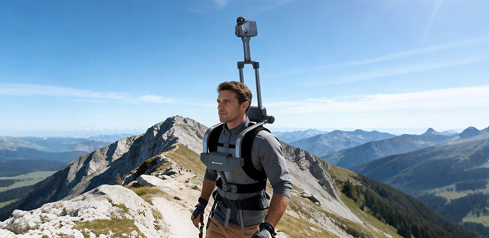
As robotics continues to evolve, the ability to accurately understand and reconstruct real-world environments is becoming just as important as movement itself. While many robots already rely on LiDAR for navigation, systems like the 3DMakerpro Raven show how dedicated LiDAR scanner surveying tools can take this capability further—transforming robots from simple navigation machines into mobile platforms capable of high-precision spatial mapping and digital reconstruction.
LiDAR Spatial Scanners: Advancing LiDAR Scanner Surveying with Raven
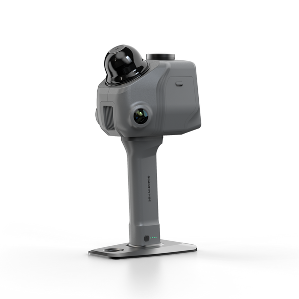
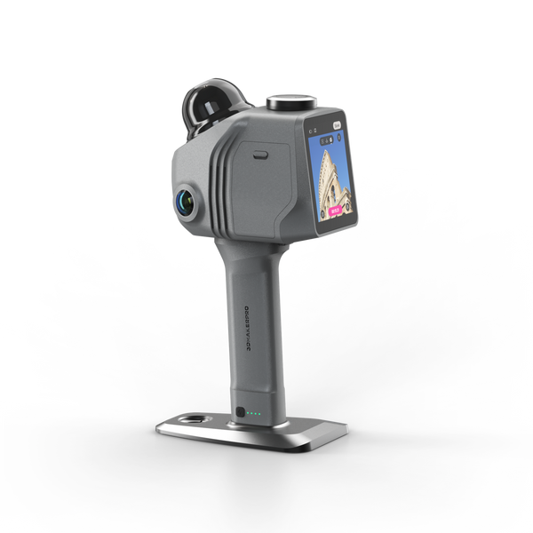
LiDAR spatial scanners are purpose-built for high-accuracy lidar surveying, going far beyond the basic sensing capabilities found in most robotic systems. The 3DMakerpro Raven exemplifies this shift, offering a balance of precision, range, and data density that is essential for professional lidar scanner surveying applications.
With an accuracy of up to 2 cm at 10 meters and a maximum scanning range of up to around 100 meters, Raven is capable of capturing both fine structural details and large environments within a single workflow. This makes it highly suitable for large-scale lidar surveying tasks, where both coverage and precision are critical.
Its 360° horizontal field of view combined with 40° vertical coverage ensures comprehensive environmental capture, reducing blind spots that can affect surveying completeness. At the same time, Raven generates dense point clouds at up to 150,000 points per second, enabling high-resolution lidar scanner surveying results that can be used for measurement, modeling, and digital twin creation.
In addition, the integration of a 12MP camera, IMU, and GPS allows for stable SLAM-based workflows, improving localization and ensuring that lidar surveying data remains accurate even in complex or dynamic environments. This combination makes Raven not just a sensor, but a complete solution for modern 3D LiDAR surveying workflows.

Robotic LiDAR: Optimized for Navigation Rather Than Surveying
Although many robots are equipped with LiDAR sensors, these systems are primarily designed for navigation rather than LiDAR scanner surveying. Typical mobile robots—such as AMRs and quadruped robots—generally rely on navigation-grade LiDAR with ranges between 10 to 30 meters, a horizontal field of view close to 270°–360°, and point output rates often below 50,000 points per second.
These specifications are sufficient for obstacle detection and path planning, where the priority is real-time responsiveness rather than data richness. As a result, the point clouds generated are relatively sparse and optimized for immediate decision-making, not for high-precision LiDAR surveying or 3D reconstruction.
In addition, many robotic LiDAR systems operate with simplified sensor fusion setups, focusing on stable localization rather than detailed spatial capture. While this allows robots to move efficiently through environments, it limits their ability to produce survey-grade lidar scanner surveying data. This gap is exactly where dedicated spatial scanners come in.

LiDAR Scanner vs Robotic LiDAR: Key Differences and Combined Value
To better understand how these technologies complement each other, it is useful to compare their core capabilities in the context of lidar scanner surveying:
| Capability | Robotic LiDAR (Navigation) | LiDAR Spatial Scanner (Raven) | Combined System Advantage |
| Primary Purpose | Navigation & obstacle avoidance | High-precision lidar scanner surveying | Simultaneous movement + mapping |
| Accuracy | Decimeter-level (typical) | Up to 2 cm @ 10 m | Survey-grade accuracy in motion |
| Recommended Surveying Range | 10–30 m (typical) | 80–100 m | Long-range coverage with consistent data quality |
| Point Cloud Density | Low to medium (<50k pts/s) | High (up to 150k pts/s) | Dense, usable 3D data while moving |
| Field of View | Partial to full horizontal | 360° × 40° | More complete environmental capture |
| Data Use | Real-time navigation only | Measurement, modeling, digital twins | Navigation + actionable spatial data |
| Workflow | Reactive | Data-driven | Autonomous lidar surveying workflows |
| System Outcome | Can move through space | Can measure and reconstruct space | Mobile, intelligent lidar surveying platform |
This comparison highlights a key insight: robotic LiDAR helps machines move efficiently, while Raven enables true LiDAR scanner surveying. Together, they create systems that can both navigate and understand environments at a much deeper level.
Combining Both: From Navigation to Mobile Lidar Surveying Systems
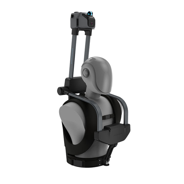
By integrating a LiDAR spatial scanner like Raven onto a robotic platform, it becomes possible to merge navigation capabilities with professional-grade LiDAR scanner surveying performance. This combination allows robots to operate not only as autonomous machines, but also as mobile data acquisition systems.
One of the most significant advantages is the ability to perform simultaneous navigation and LiDAR surveying. While the robot’s onboard sensors handle obstacle avoidance and movement, Raven captures dense, high-accuracy spatial data in parallel. This separation ensures that neither navigation nor surveying performance is compromised.
This integration also enables continuous mobile LiDAR surveying workflows, where environments are scanned and updated in real time as the robot moves. Instead of relying on static scans, users gain access to dynamic 3D models that reflect current site conditions—an essential capability in industries like construction and facility management.
In inspection scenarios, the benefits are even more pronounced. Robots can access hazardous or hard-to-reach areas, while Raven provides the detailed data required for precision LiDAR surveying and analysis. This improves safety while delivering higher-quality results compared to manual methods.
Across industries, this combination is driving new applications for lidar scanner surveying. In construction, it supports automated site mapping and progress tracking. In logistics and warehousing, it enables spatial optimization based on accurate 3D data. In infrastructure inspection, it allows for a detailed condition assessment without exposing workers to risk. In each case, the integration of robotics and LiDAR transforms traditional surveying into a faster, safer, and more scalable process.
Conclusion
Robotic systems with built-in LiDAR have already redefined navigation, but their capabilities remain limited when it comes to high-quality LiDAR scanner surveying. Dedicated solutions like the 3DMakerpro Raven fill this gap by delivering the accuracy, density, and reliability required for true 3D spatial capture.
When combined, robotics and LiDAR spatial scanners create a new class of systems capable of both movement and measurement—enabling continuous, intelligent LiDAR surveying workflows across industries. As demand for accurate spatial data continues to grow, this integration will play a central role in the future of automation, mapping, and digital transformation.


Featured collection
LiDAR scanner
Save $255.00
Raven LiDAR Scanner
Backpack Kit


