Content

LiDAR technology has revolutionized industries ranging from autonomous vehicles to environmental mapping. With its ability to generate high-precision 3D spatial data, LiDAR is paving the way for future innovations in automation, smart cities, and industrial applications. But what does the future hold for LiDAR, and how will these advancements shape the way we perceive and interact with our surroundings?
The Next Wave of LiDAR Advancements
1. Higher Accuracy and Extended Range
LiDAR systems are continually evolving to offer higher accuracy and extended range. Modern advancements in beam steering technology and sensor miniaturization are allowing for more precise data collection. The next generation of LiDAR sensors is expected to achieve centimeter-level accuracy at greater distances, enhancing applications in surveying, construction, and autonomous navigation.

2. Solid-State LiDAR: The Future of Compact Scanning
Traditional mechanical LiDAR systems rely on rotating mirrors to scan an environment, but solid-state LiDAR is emerging as a game-changer. By eliminating moving parts, solid-state LiDAR improves durability, reduces costs, and enhances real-time 3D mapping capabilities. This shift is particularly beneficial for integration into personal devices, drones, and compact autonomous systems.
3. AI-Enhanced LiDAR: Smarter Data Processing
Artificial intelligence (AI) is increasingly being integrated into LiDAR systems to enhance data processing. AI-driven algorithms can automate object recognition, improve point cloud filtering, and optimize real-time decision-making. In smart cities, AI-enhanced LiDAR can analyze traffic patterns, pedestrian movement, and urban planning scenarios with greater efficiency.

4. Multi-Spectral and FMCW LiDAR: Expanding Capabilities
Multi-spectral LiDAR is set to redefine environmental monitoring by capturing data across multiple wavelengths, allowing for better material classification and vegetation analysis. Meanwhile, Frequency Modulated Continuous Wave (FMCW) LiDAR is gaining traction for automotive applications, offering superior depth perception and better resistance to signal interference.
5. Portable and Handheld LiDAR Scanners
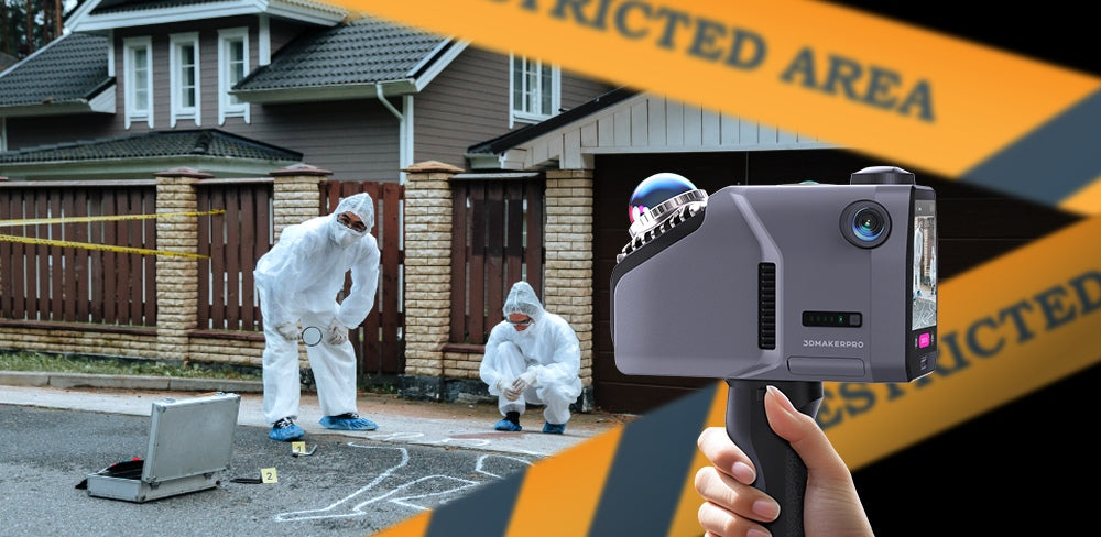
As LiDAR technology becomes more accessible, the demand for portable and handheld scanning solutions is increasing. These compact LiDAR systems enable professionals in fields like architecture, forensics, and archaeology to capture high-resolution spatial data on the go.

LiDAR’s Role in Future Industries
a) Autonomous Vehicles and Smart Mobility
LiDAR remains a critical component in the development of autonomous vehicles, enabling precise environmental mapping and obstacle detection. Future advancements will further refine autonomous navigation under adverse weather conditions, improving safety and reliability.

b) Urban Planning and Smart Cities
LiDAR is playing a key role in the development of smart city infrastructure. By providing detailed 3D models of urban environments, city planners can optimize traffic flow, enhance public transportation systems, and improve disaster response strategies.
c) Industrial and Construction Applications
From large-scale site surveys to precision manufacturing, LiDAR technology is transforming industrial workflows. The ability to generate highly accurate digital twins of construction sites and machinery ensures better project management and resource allocation.

d) Environmental Monitoring and Conservation
LiDAR’s ability to penetrate dense vegetation makes it an invaluable tool for environmental studies. Researchers can use LiDAR to track deforestation, monitor coastal erosion, and assess climate change impacts with unparalleled accuracy.
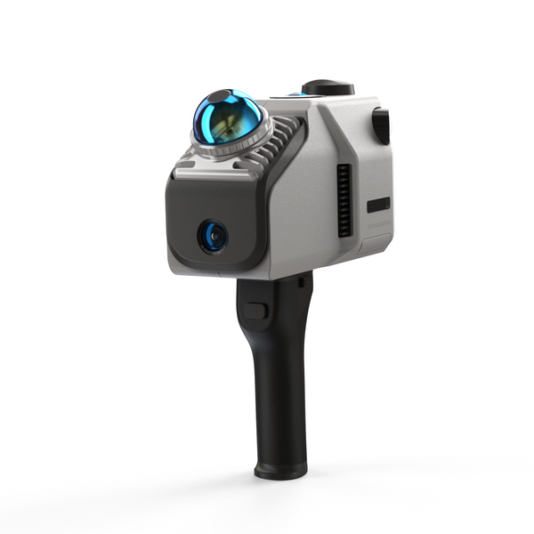
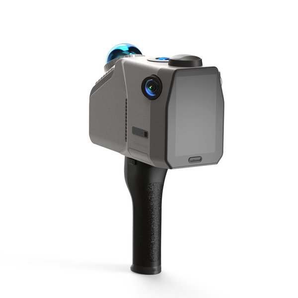
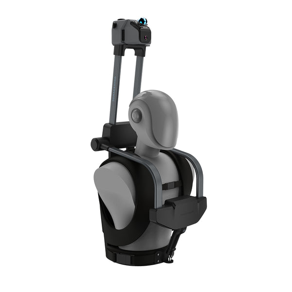
Introducing the Next Generation of LiDAR Scanners
Leading the charge in LiDAR innovation, 3DMakerpro’s Eagle LiDAR Scanner is redefining spatial scanning with its advanced capabilities. Designed for professionals in architecture, surveying, and 3D modeling, the Eagle LiDAR Scanner delivers:
Ultra-Wide 360° Field of View for comprehensive spatial capture
8K Ultra Imaging for high-resolution 3D modeling
Up to 140m Scan Range for large-scale applications
AI-Enhanced Data Processing for precision modeling and real-time feedback
With its handheld, lightweight design, the Eagle LiDAR Scanner is built for versatility, seamlessly integrating into various industrial and creative workflows. Whether mounted on a vehicle, drone, or used as a portable scanning tool, Eagle ensures unmatched performance in spatial data collection.

Optimize Your Workflow with RayStudio
To maximize the potential of Eagle LiDAR Scanner, RayStudio software provides an advanced platform for processing and refining LiDAR data. RayStudio simplifies the workflow with intuitive tools for:
Point Cloud Resolution – Easily convert raw scan data into high-precision 3D models.
Colorization & Texture Mapping – Enhance scanned models with realistic textures and colors.
Real-Time RTK Processing – Optimize GPS trajectory data for surveying applications.
3D Gaussian Splatting – Generate ultra-realistic 3D environments, ideal for game development, virtual tours, and digital twins.
With RayStudio, users can effortlessly edit, refine, and export their scanned data in multiple formats, including PLY, OBJ, and LAS, making it the perfect companion for Eagle LiDAR Scanner.

The Future of LiDAR Technology
LiDAR technology is rapidly advancing, with innovations in AI integration, solid-state design, and extended scanning capabilities shaping its future. As industries continue to adopt LiDAR for automation, urban development, and environmental conservation, tools like the Eagle LiDAR Scanner are leading the way.
For professionals and enthusiasts looking to embrace the future of 3D mapping, 3DMakerpro’s Eagle LiDAR Scanner provides the perfect balance of precision, portability, and performance. Explore the future of spatial scanning and unlock new possibilities in digital transformation. Discover the power of Eagle LiDAR Scanner today!


Featured collection
LiDAR scanner
Eagle LiDAR Scanner
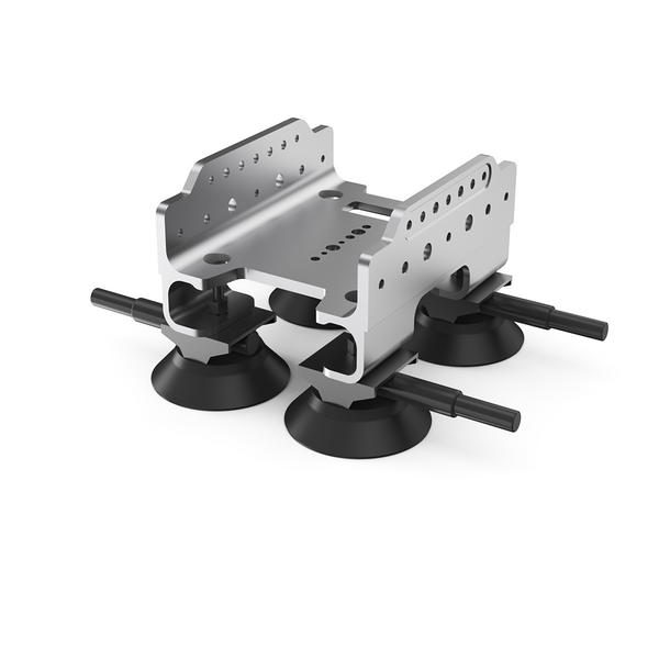
Automotive Rooftop Mount


