Contenu
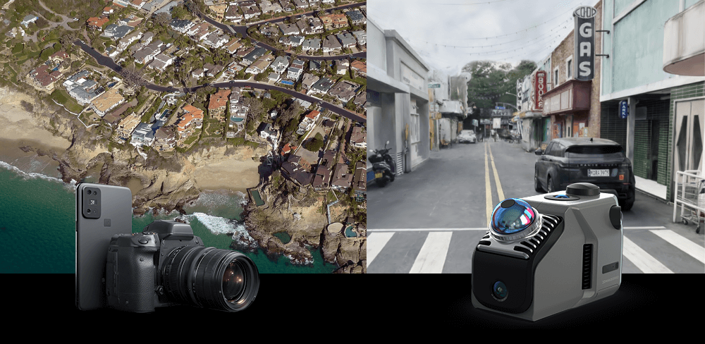
Photogrammétrie et LiDAR sont deux technologies de pointe dans la capture de données 3D, chacune avec des atouts uniques. Photogrammétrie utilise des images pour créer des modèles, tandis que le LiDAR, souvent appelé radar laser, utilise des impulsions laser pour des mesures de distance précises. Alors que des secteurs comme la construction, l'arpentage et la préservation du patrimoine adoptent de plus en plus les flux de travail 3D, il est essentiel de comprendre quand utiliser chaque méthode. Ce guide compare les deux approches pour vous aider à choisir l'outil le mieux adapté à vos besoins.
Qu'est-ce que la photogrammétrie
"Photogrammétrie est la science et la technologie permettant d'obtenir des informations fiables sur les objets physiques et l'environnement grâce au processus d'enregistrement, de mesure et d'interprétation d'images photographiques et de modèles d'imagerie radiante électromagnétique et d'autres phénomènes.
Il existe de nombreuses variantes de photogrammétrie. Un exemple est l'extraction de mesures tridimensionnelles à partir de données bidimensionnelles (c'est-à-dire des images) ; par exemple, la distance entre deux points situés sur un plan parallèle au plan de l'image photographique peut être déterminée en mesurant leur distance sur l'image, si l'échelle de celle-ci est connue. Un autre exemple est l'extraction de gammes et de valeurs de couleurs précises représentant des quantités telles que l'albédo, la réflexion spéculaire, la métallicité ou l'occlusion ambiante à partir de photographies de matériaux, à des fins de rendu physique. de Wikipédia

Qu'est-ce que le Lidar
Le lidar (aussi appelé LIDAR, acronyme de « light detection and ranging » ou « laser imaging, detection, and ranging » ) est une méthode permettant de déterminer la distance en ciblant un objet ou une surface avec un laser et en mesurant le temps de retour de la lumière réfléchie vers le récepteur. Le lidar peut fonctionner dans une direction fixe (par exemple, verticale) ou dans plusieurs directions, combinant balayage 3D et balayage laser.
Le lidar a des applications terrestres, aériennes et mobiles. Il est couramment utilisé pour réaliser des cartes haute résolution, avec des applications en topographie, géodésie, géomatique, archéologie, géographie, géologie, géomorphologie, sismologie, foresterie, physique atmosphérique, guidage laser, cartographie laser aéroportée (ALSM) et altimétrie laser. de Wikipédia

Photogrammétrie vs LiDAR : une comparaison
| Paramètre | Photogrammétrie | LiDAR général | Scanner LiDAR Eagle |
| Précision | 2 à 5 cm dans des conditions idéales | 1 à 3 cm typique ; LiDAR de qualité topographique ≤ 1 cm possible | 2 cm à 10 m, 3 cm à 20 m, 5 cm à 40 m |
| Vitesse de numérisation | Plus lent ; dépend du nombre d'images et du temps de traitement | Rapide ; numérisation en temps réel jusqu'à 1 000 000 pts/sec dans les modèles haut de gamme | 200 000 points/s, scanne 150 m × 150 m en < 5 min, prend en charge les déplacements à 20 km/h |
| Gamme de balayage | Limité par l'altitude de la caméra et du drone ; souvent à 50–100 m du sujet | Varie considérablement : courte portée (30–70 m) , longue portée (jusqu'à plusieurs centaines de m) | rayon de 40 à 70 m (>10–80 % de réflectivité) , Portée effective de 80 à 140 m |
| Angle de balayage (FOV) | Cela dépend de l'objectif de l'appareil photo ; des images généralement plus étroites et superposées sont requises | Généralement 360° horizontal, 30–70° vertical | 360° horizontal, 59° vertical |
| Méthode d'imagerie | Utilise des photographies RVB ou multispectrales 2D pour reconstruire des modèles 3D | Utilise des impulsions laser pour mesurer directement les distances | Utilise la lumière laser (905 nm, classe 1) plus Appareil photo 48MP pour des panoramas 8K HDR |
| Prise en charge du nuage de points de couleur | Oui (à partir des textures d'image) ; généralement mappées par la suite | Rarement (sauf associé à un appareil photo ou à des capteurs multispectraux) | Oui, prend en charge les nuages de points en vraies couleurs et les textures panoramiques |
| Formats de sortie | Orthophotographies, maillages texturés, MNT, nuage de points (par exemple, OBJ, GeoTIFF, PLY) | Formats de nuages de points (LAS, PLY, E57) ; parfois scans 3D bruts | PLY, PNG+OBJ, splash gaussien PLY, prend en charge les sorties itinérantes |
| Prise en charge SLAM | Non (nécessite des points de contrôle GPS/géolocalisés) | Disponible dans de nombreux systèmes LiDAR mobiles modernes | Oui, avec SLAM intérieur/extérieur en temps réel + coordonnées GPS/relatives |
| Dépendance à l'éclairage | Nécessite un bon éclairage ; ne peut pas fonctionner dans l'obscurité | Insensible à l'éclairage ; fonctionne dans les zones sombres, la nuit ou ombragées | Fonctionne dans toutes les conditions d'éclairage, prend en charge le HDR et la capture 3D en basse lumière |
| Poids | < 1, 5 kg | 1–10+ kg | 1, 5 kg |
| Batterie et autonomie | Généralement 20 à 30 minutes par vol de drone | Durée de 1 à 5 heures | 12000mAh, 1 heure de fonctionnement, prend en charge la charge pendant l'utilisation |
Applications de la photogrammétrie
a) Patrimoine culturel et architecture
Photogrammétrie La numérisation 3D est largement utilisée pour la préservation et la documentation du patrimoine culturel. Grâce à la capture d'images haute résolution, les professionnels peuvent reconstituer des modèles 3D précis de bâtiments, monuments et objets historiques. Ces modèles facilitent les travaux de restauration, permettent des expositions virtuelles et servent de documents numériques à long terme en cas de dommage ou de perte. Selon des études récentes, plus de 70 % des projets mondiaux de conservation du patrimoine intègrent désormais une forme de numérisation 3D ou de numérisation. photogrammétrie, ce qui reflète son importance croissante dans la préservation du patrimoine culturel. Dans le domaine de l'architecture, plus de 60 % des professionnels déclarent utiliser des modèles photogrammétriques pour la planification de la rénovation et l'analyse visuelle.

b) Construction et immobilier
Photogrammétrie transforme les flux de travail de la construction en permettant une surveillance de chantier plus rapide et plus précise. La capture d'images par drone peut réduire le temps de collecte de données sur le terrain jusqu'à 80 %, tout en permettant le suivi de l'avancement des travaux, l'estimation du volume de matériaux et la vérification de la conformité. Les géomètres et les ingénieurs constatent que photogrammétrie Améliore la productivité sur site et réduit les reprises. Dans l'immobilier, les propriétés enrichies de visualisations 3D ou de visites virtuelles ont enregistré une augmentation moyenne de l'engagement en ligne allant jusqu'à 300 %, les acheteurs étant plus réceptifs aux représentations immersives et détaillées.
c) Agriculture et surveillance environnementale
En agriculture, photogrammétrie favorise une gestion agricole plus efficace en fournissant des images détaillées permettant d'analyser la santé des cultures, l'efficacité de l'irrigation et la variabilité des champs. Des études montrent que les exploitations agricoles utilisant des images aériennes photogrammétrie peuvent atteindre des rendements supérieurs de 10 à 25 % grâce à la détection précoce de problèmes tels que les infestations de ravageurs ou le stress nutritionnel. En matière de surveillance environnementale, photogrammétrie Il permet de suivre l'évolution de l'utilisation des terres, l'érosion des berges et la croissance de la végétation. Il permet aux chercheurs de surveiller et de mesurer des zones avec une précision spatiale de 2 à 5 cm, même dans les écosystèmes éloignés ou sensibles.
d) Arpentage et cartographie
Photogrammétrie offre une méthode économique et évolutive pour l'arpentage et la cartographie topographique, notamment dans les zones difficiles d'accès à pied. Elle permet la création d'orthophotographies, de cartes de courbes de niveau et de modèles numériques de surface précis. Comparé à la topographie traditionnelle au sol, photogrammétrie Elle peut réduire les délais de projet jusqu'à 70 % tout en conservant une précision centimétrique. Son intégration aux systèmes d'information géographique (SIG) prend en charge les applications d'urbanisme, de développement des infrastructures et de gestion des ressources naturelles. La demande mondiale de données photogrammétriques ne cesse de croître, portée par le développement rapide des secteurs de la construction, de l'agriculture et de la protection de l'environnement.

e) Expertise médico-légale et reconstitution d'accidents
Photogrammétrie est de plus en plus utilisé en criminalistique et en reconstitution d'accidents de la route en raison de sa rapidité, de sa précision et de sa capacité à documenter les scènes sans contact physique. Il permet aux enquêteurs de créer des modèles 3D de scènes de crime ou de lieux d'accident en quelques minutes, préservant ainsi les détails susceptibles d'être altérés ou perdus au fil du temps. Des études montrent que l'utilisation de ces techniques photogrammétrie peuvent réduire le temps d'enquête sur place de 50 à 70 % tout en améliorant la précision et la clarté de la documentation de la scène. Ces modèles sont également utiles au tribunal, où les preuves visuelles en 3D sont plus percutantes et plus faciles à comprendre que les photographies ou les croquis traditionnels.
Applications du LiDAR
a) Cartographie urbaine et urbanisme
La technologie LiDAR est essentielle à l'urbanisme, car elle permet aux urbanistes de capturer la forme et la structure des villes avec une précision extrême. Scanners Eagle LiDAR Grâce à l'imagerie panoramique ultra-nette 8K HDR et au système à 4 caméras 48 MP, les professionnels peuvent créer des cartes 3D riches en images et aux couleurs précises, idéales pour la modélisation urbaine, la surveillance des infrastructures et le développement de villes intelligentes. La précision de 2 cm à 10 mètres du scanner garantit des mesures géométriques fiables, nécessaires à des tâches telles que la conception d'aménagements de services publics, l'évaluation des surfaces routières et l'aménagement des espaces publics. La capacité à couvrir une grande surface (150 m x 150 m en moins de 5 minutes) améliore considérablement l'efficacité des projets de grande envergure.

b) Infrastructures de transport et gestion des routes
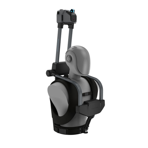
Le LiDAR est largement utilisé dans les infrastructures de transport pour la cartographie des autoroutes, des voies ferrées, des tunnels et des ponts. Le rayon de balayage de 70 m et la vitesse de capture de mouvement de 20 km/h du scanner Eagle le rendent particulièrement adapté à la numérisation mobile, idéal pour la capture de longs corridors tels que les routes et les voies ferrées. Les ingénieurs peuvent utiliser ces données pour évaluer l'usure, calculer les dégagements et planifier les extensions. Les modes de capture multipoints de vue (vue à la première personne, aérienne et à 45 degrés) permettent une documentation efficace des caractéristiques sous différents angles, offrant une compréhension complète des environnements routiers. Cette polyvalence garantit une modélisation précise, même dans les zones difficiles d'accès ou dangereuses.
c) Surveillance forestière et environnementale
Dans les études forestières et écologiques, la capacité du LiDAR à pénétrer la végétation le rend précieux pour évaluer la hauteur des arbres, la densité de la canopée et la répartition de la biomasse. Alors que le LiDAR traditionnel se concentre uniquement sur la géométrie, le scanner LiDAR Eagle va plus loin en combinant nuages de points couleur et imagerie haute résolution, offrant un contexte visuel détaillé aux données géométriques. Les chercheurs peuvent utiliser ces données pour étudier la santé de la végétation, les schémas d'érosion et l'évolution de la couverture terrestre. De plus, grâce à la navigation SLAM et au positionnement absolu et relatif par GPS, l'Eagle est capable de suivre des itinéraires et de cartographier des environnements, même dans des forêts denses ou des terrains accidentés, sans nécessiter de signaux satellites en permanence.

d) Modélisation de bâtiments et cartographie intérieure
Le LiDAR est idéal pour créer des modèles d'information du bâtiment (BIM) précis et des cartes intérieures détaillées d'environnements complexes. Le scanner LiDAR Eagle excelle dans ce domaine grâce à la technologie SLAM (localisation et cartographie simultanées) qui permet de créer des cartes 3D en temps réel, même dans des environnements à plusieurs étages et aux angles étroits. Qu'il s'agisse de numériser un bâtiment historique à des fins de préservation ou de documenter un chantier en cours, sa compacité (1, 5 kg) et sa portabilité facilitent sa maniabilité en intérieur. La sortie de texture couleur du scanner, combinée à la prise en charge de plusieurs formats de fichiers (tels que OBJ et PLY) , garantit la compatibilité avec les logiciels d'architecture et d'ingénierie.
e) Analyse minière, géologique et de terrain
Dans le domaine minier et géologique, le LiDAR permet aux professionnels de calculer des volumes, de cartographier le terrain et de surveiller la stabilité des pentes. Le scanner Eagle, avec sa fréquence de nuage de points de 200 000 points par seconde et sa prise en charge des formats d'éclaboussures gaussiennes, fournit des données denses et détaillées, même sur des terrains irréguliers. Son laser de classe 1, sans danger pour les yeux, garantit un fonctionnement sûr, aussi bien en surface que sous terre. Les géologues peuvent rapidement scanner de vastes fosses minières ou formations rocheuses avec l'assurance que les modèles obtenus reflètent à la fois la couleur et la précision géométrique, facilitant ainsi les évaluations géologiques et la planification de la sécurité.
f) Patrimoine culturel et préservation des sites
Pour la documentation et la préservation des monuments historiques et des sites archéologiques, le LiDAR offre une numérisation non intrusive et de haute précision. Le scanner LiDAR Eagle optimise cette qualité grâce à des images HDR 8K éclatantes, garantissant que les modèles numérisés conservent leurs couleurs et textures authentiques, essentielles à l'archivage, à la restauration et à la présentation virtuelle. Son fonctionnement sans GPS (grâce au SLAM) le rend idéal pour les ruines intérieures, les grottes ou les ruelles étroites, tandis que la rapidité du processus de numérisation garantit une perturbation minimale des zones sensibles. Grâce aux options de sortie multiformat, les données sont prêtes pour la visualisation, l'analyse ou l'impression 3D.

Si la photogrammétrie offre une grande précision visuelle, le LiDAR se distingue par sa rapidité, sa précision et ses performances dans les environnements complexes ou à faible luminosité. Des outils avancés comme le scanner Eagle LiDAR offrent une imagerie haute résolution, une cartographie SLAM en temps réel et des résultats fiables, même sans GPS. Pour les professionnels qui ont besoin de données rapides, détaillées et fiables, le LiDAR est souvent le choix le plus judicieux.
Collection vedette
LiDAR scanner
Economisez $800.00
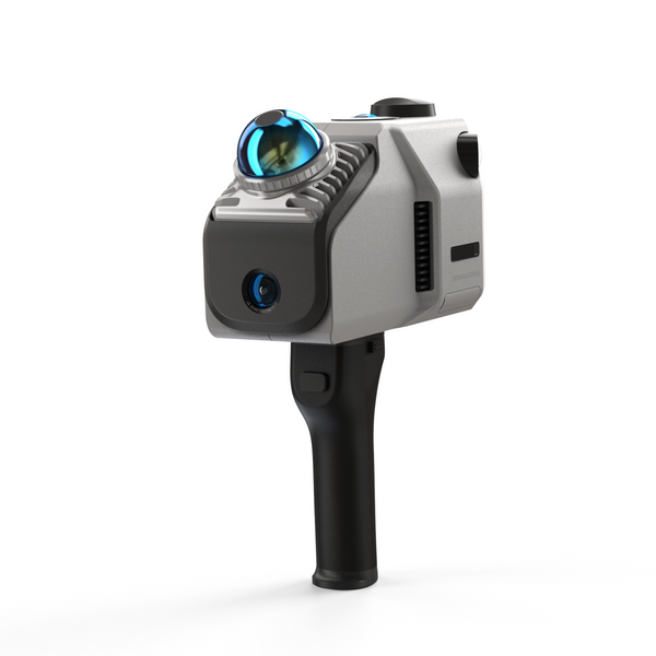
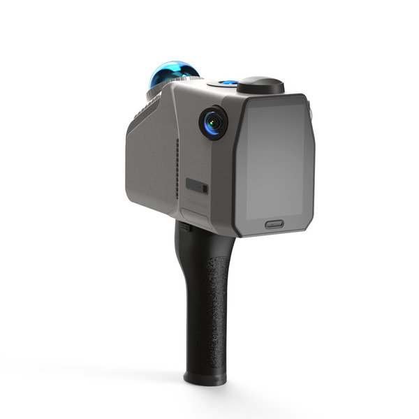
Scanner LiDAR Eagle
Module d'antenne et de signal RTK


